| Index | ||
|---|---|---|
| Raster Files | A-Z |
remember, a raster in IDRISI carries no information about 'itself' - we need to store that metadata separately. This is done by so-called raster documentation files (*.DOC). All images must have their corresponding DOC-files. These are ASCII files made up by a sequence of lines, each representing metadata. To ease handling, IDRISI comes with a tool called DOCUMENT:
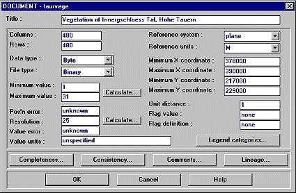
You see a lot of fields which can be divided into obligate and facultative ones.
| obligate | facultative | notes | |
|---|---|---|---|
| Titel | X | purely descriptiv, use it! | |
| Columns / Rows | X | determines raster structure | |
| Data type | X | type of values | |
| File type | X | how is the file stored | |
| Minimum / Maximum value | X | automatic checking of limits possible | |
| Pos'n error | X | x,y-position error assessment as RMS error | |
| Resolution | X | resolution of each cell; automatic calculation: MaxX - MinX / columns; does not always mean the 'true' spatial resolution | |
| Value error | X | attribute value error, proportional or RMS, used in the calculation of the module PCLASS | |
| Value units | X | m, classes, kg*ha-1*a-1 or any other unit | |
| Reference system | X | projectioninformation | |
| Reference units | X | m, ft, km, mi, deg, rad | |
| Minimum / Maximum X/Y coordinates | X | image extents | |
| Unit distance | X | a scaling factor, usually 1.0; eg. 2.0 and reference units meters would mean: a distance of 1 unit represents 2 meters in real | |
| Flag value | X | a value in your raster with special meaning (background value, nodata, ...); analytically used by SURFACE, FILTER | |
| Flag definition | X | description of above values meaning | |
| Legend categories | X | text for legend | |
| Completness, Consitency, Comments and Lineage | X | descriptive, use it if you have information | |
As indicated, several fields are purely descriptive. Nevertheless it is highly recommended to provide any additional information about the data to help assure higher accuracy.
| Index | ||
|---|---|---|
| Raster Files | A-Z |
last modified: | Comments to Eric J. LORUP