![]()
![]()
|
|
|
|---|---|---|
Let our interest now focus on maybe distinct zones: what is the maximum height throughout all the areas of vegetation class 16? What is its mean height? Or even more expressive - its range?
EXTRACT helps you in finding a solution to that spatially complex questions:
 During several lessons I often found it a bit difficult for students to grasp what 'zones'
are, when they first heard about it. No magic around, so - de-mystifying - zones
are nothing but 'a set of data pertaining to one of the variations' in an
image (TOMLIN, p. 10). So all the pixels with value 16
in our image together define the zone for value 16.
During several lessons I often found it a bit difficult for students to grasp what 'zones'
are, when they first heard about it. No magic around, so - de-mystifying - zones
are nothing but 'a set of data pertaining to one of the variations' in an
image (TOMLIN, p. 10). So all the pixels with value 16
in our image together define the zone for value 16.
Areas belonging to a zone may vary in shape, they may be scattered all over our image or just be represented by one patch. Important is: the 'zone' embraces all those patches and areas in our image as a whole for the calculations.
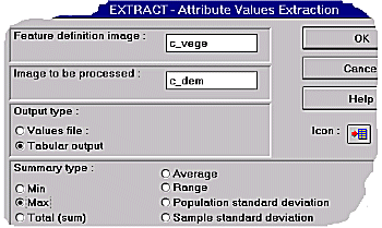
What's the maximum summary type doing? It looks for the least value throughout every
zone. How does IDRISI get to know about zones? By entering a 'Feature definition image'
(look at dialogbox). Where do the values (for the maximum values search) come from? They
are stored in the image we type in 'Image to be processed' (dialogbox). As a result IDRISI
faces us with a table or a values file with the summary-listing for the maximum-values for
each zone.
So remember the sample images from the preceding chapter about the boolean operations. Now let us pick up such a 'zone' from the TAURVEGE dataset, e.g. vegetation class 16 and try to answer the question in the first paragraph of this page. For convenience the resulting tables from 4 subsequent EXTRACT-sessions have been put together:
Maximum values extracted from c_dem based on c_vege Category maximum ---------------------- 0 0.000000 1 3005.000000 2 2768.000000 3 2752.000000 4 2585.000000 5 2563.000000 6 2371.000000 7 2306.000000 8 1597.000000 9 1326.000000 10 2053.000000 11 2483.000000 12 2316.000000 13 2107.000000 14 2288.000000 16 2217.000000 18 2210.000000 19 2151.000000 20 2146.000000 22 1782.000000 23 1493.000000 24 1539.000000 25 2064.000000 26 1781.000000 27 2248.000000 28 1512.000000 29 2955.000000 30 2744.000000 31 2827.000000 |
Range extracted from c_dem based on c_vege range --------------- 0.000000 1456.000000 986.000000 1163.000000 648.000000 1187.000000 1054.000000 872.000000 104.000000 6.000000 251.000000 1038.000000 802.000000 76.000000 776.000000 881.000000 485.000000 513.000000 774.000000 259.000000 59.000000 40.000000 605.000000 223.000000 790.000000 18.000000 825.000000 1286.000000 1049.000000 |
Average values extracted from c_dem based on c_vege average -------------------- 0.000000 2504.381592 2369.511963 2314.930420 2305.068604 2076.591797 1831.569946 1776.380005 1512.675293 1323.000000 1926.371460 2124.806885 1952.322754 2067.333252 1850.957520 1832.449463 1946.748413 1893.650879 1683.381470 1622.614868 1466.476196 1506.329468 1736.760986 1653.132080 1928.270752 1500.677734 2595.644043 2214.259521 2448.753174 |
Pop. SD extracted from c_dem based on c_vege population standard deviation ------------------ 0.000000 210.497955 155.876114 146.568085 163.373474 232.300858 271.871185 245.223694 13.514922 2.449490 71.104385 135.756699 166.755127 23.584364 182.762695 147.938126 84.431808 109.676735 128.012512 57.986622 17.589550 7.656429 123.231606 42.241016 136.568451 2.839514 176.245438 275.286438 325.876984 |
From the results above we could say: vegetation class 16 climbs up to a height of 2217
m a.s.l.
But: perhaps the images we compared do not match exactly, perhaps there has been some
error of the field team, perhaps ...
|
|
|
|---|---|---|
last modified: | Comments to Eric J. LORUP