|
|
Index |
|
|---|---|---|
| Raster Files | A-Z | Attribute Value Files |
primarily IDRISI is raster-based, but vectors can be used to get data from other sources into IDRISI. Further they serve as overlays for better visual orientation. We can digitize vector-polygons onscreen during the process of supervised image classification to define our training areas, and we will tell IDRISI where to put texts in our maps through vector-points.
See how IDRISI vector-files are structured:
Id   n
 x1   y1
 x2   y2
 x3   y3
 ......
 xn   yn
Id   n
 x1   y1
 x2   y2
 ......
 ......
0   0
2 columns, 1st line holds an identifier (integer or real) plus the number of
coordinates following (in case of point-files = 1). As many lines as specified
before define the vertex-coordinates. Each vector-file has to end with
0 0 (zero zero).
Polygon-vectors are cycled in that the last X/Y-pair equals the first one for each
single polygon.
Let us take height-data (eg. from a GPS) as an example for a point-vector file:
1211  1
 212328.0  424876.0
1250  1
 212400.0  425090.0
1283  1
 213222.5  426112.5
......
1423  1
 215089.2  428987.6
1423  1
 215234.0  429876.7
0   0
See? Identifiers need not be unequivocal. In this case they mean the heights of the points.
Vector Documentation Files
The vector-file too is a 'dumb thing', that has to be told about its nature, so
every IDRISI vector-file (*.VEC) comes with a vector documentation file (*.DVC).
The module DOCUMENT again helps to input the metadata:
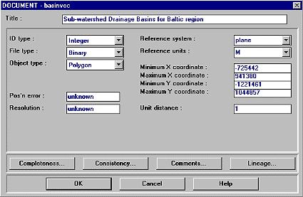
You'll find one additional field - Object type - which can be Point, Line, Polygon or Text. Of course you can not automatically calculate the vectors resolution. It is your responsibility to put in a value if known. The remaining fields have same meanings as with raster documentation.
|
|
Index |
|
|---|---|---|
| Raster Files | A-Z | Attribute Value Files |