concentrating on essentials
Not yet done
| Index | ||
|---|---|---|
| Image Processing IV (cont.) concentrating on essentials |
A-Z | To do's Not yet done |
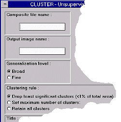
| Think of a case, that you do not know much about the real landcover classes in your satellite image (e.g., very out-of-the-way areas). A method to get more information from your data is what's known as unsupervised classification. By that we mean a whole family of techniques, from which IDRISI uses one, called 'histogram peak technique'. For details read the IDRISI help files. The method relies on RGB-images created with COMPOSIT: the spectral information from 3 different bands has been converted to a index number in the range 0 - 215. CLUSTER computes same way back and internally produces 3-dimensional histograms for the 3 bands used. |
|
|
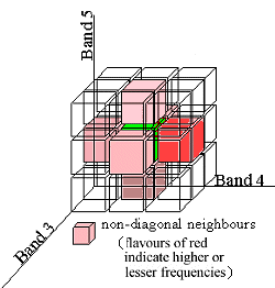
Classes are identified as histogram 'peaks' (spoken 3-dimensional: centres of high frequency). Membership to a class is defined by the neighbourhood to such a 'peak'. In the case of broad generalization a class is defined by having a frequency higher than all of its non-diagonal neighbours. The fine generalization type allows for one non-diagonal neighbour with a higher frequency. |
You will also recognize three different clustering rules. What combination of parameters should we choose now? To a high degree image processing and interpreting is a matter of experience, trial and error. The same holds true here.
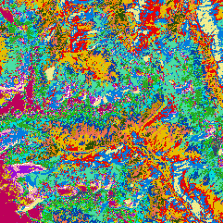
One approved way is to select fine generalization plus retaining all clusters to get an idea of the number of clusters to expect. Use histogram to explore the frequencies and their distribution.
| fine generalization - retain all clusters | histogram for image to the left |
|---|---|
|

|
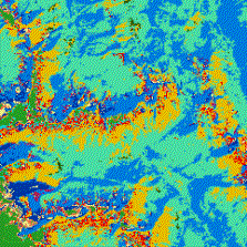
41 classes are of course not realistic for a Landsat TM 5 classification in a mountainous environment like the one in question. Search for significant breaks in the histogram, e.g., after 4, 6, 8 (11, 15, ...). Use CLUSTER with same input as before but set maximum cluster numbers to some break value, e.g., 11. Below are two examples from such an explorative attempt (both overlaid by vegetation boundary from analog map):
|
fine generalization set maximum number of clusters to 11 |
broad generalization set maximum number of clusters to 11 |
|---|---|

|
|
Some regions show resonable match others don't. The final task that's up to you is to interpret classes, related them to real world objects and land cover types.
| Index | ||
|---|---|---|
| Image Processing IV (cont.) concentrating on essentials |
A-Z | To do's Not yet done |