Shape analysis with PERIM and CRATIO
| Index | |
|---|---|
| Single Raster Analysis Tools II Shape analysis with PERIM and CRATIO |
A-Z |
We were talking about AREA, we used it together with PERIM to achieve some form describing index. As with all spatial data we should be aware of some errors, of certain inaccuracies attached to our input as well as to our output results. So a thorough knowledge about the fundamental concepts how software does its calculations is desired.
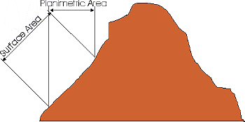
How does AREA work? Rather simple, in that it counts all the cells with same attribute value in an image and computes area as this number times cellwidth times cellheight (in reference units). One single cell is assumed to be plane. If our region of interest is situated in nearly flat landscape, that may be a minor problem. But the steeper our surface the more there will be a considerable difference between the 'Planimetric' and the 'Surface' area.
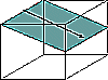
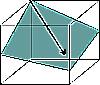
| Surface vs. Planimetric Area | Cardinal vs. Diagonal Direction |
|
|---|---|---|
 |
 |
 |
| Cardinal Direction | ||
 |
||
| Diagonal Direction |
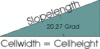
As is clearly seen, the surface area will always be larger. WEIH (1994)* presented a method, how to cope with that, at least approximative: we can distinguish between 'Cardinal' and 'Diagonal' direction for each of the single cells. Cardinal means exposed to N, S, E or W, Diagonal denotes to cells with expositions other than N, S, E, W. A simple trigonometric function helps us to compute the slopelength of one pixel, which in turn may be used for the area calculation. Anybody interested in how to implement that in IDRISI, please contact the author of these webpages.
| Index | |
|---|---|
| Single Raster Analysis Tools II Shape analysis with PERIM and CRATIO |
A-Z |
last modified:| Comments to Eric J. LORUP