| Index | ||
|---|---|---|
| Datatypes | A-Z | GIS Analysis |
Before starting to analyze, process and squeeze your data with IDRISI, you have to tell it where to find them. All working data (eg. for a project) are commonly stored in one directory. That's the reason, why IDRISI does not meet the conventional menu structure of most WINDOWS programs (File, Edit, ...) - instead of opening files first, you have to point IDRISI to the directory holding your project data. This is done by ENVIRON. IDRISI stores that path until you change it, in a simple ASCII-file (IDRISI.ENV) which resides in the IDRISIW program directory:
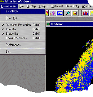
Be careful, where to put the data, as you will get problems if the path is too deep (more than 28 characters). Avoid Windows 95 or Windows NT compliant file naming schemes for your IDRISI data, as of now IDRISI is still a 16-bit software and does not allow longer file names.
If you are new to IDRISI make use of the Shortcut module, which opens up a list of all the modules available within IDRISI, so you do not have to remember the exact way how to find the function in the menu jungle.
In general IDRISI modules take(s) one (to many) image(s) as input and calculate one (to many) output raster file(s). Several modules face you with table results or both. Others output graphs. To avoid inadvertently overwriting, switch on the Overwrite Protection in the ENVIRONMENT menue.
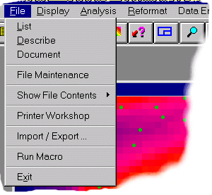
The main suite of data organizing modules is found in the File menue:
| Index | ||
|---|---|---|
| Datatypes | GIS Analysis |
last modified: | Comments to Eric J. LORUP